Mass Confusion over FCC Mapping

You might not be surprised to hear that I am tired of talking about the FCC map. I spend way too much time these days answering questions about the maps. I understand why folks are confused because there are several major mapping timelines and issues progressing at the same time. It’s nearly impossible to understand the significance of the many dates that are being bandied around the industry.

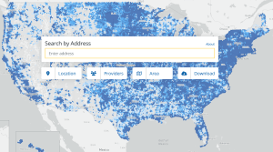
The first issue is the FCC mapping fabric. The FCC recently encouraged state and local governments and ISPs to file bulk challenges to the fabric by June 30. This is the database that attempts to locate every location in the country that can get broadband. The first mapping fabric issued in June 2022 was largely a disaster. Large numbers of locations were missing from the first fabric, while the fabric also contains locations that don’t exist.

Most experienced folks that I know in the industry are unhappy with the fabric because its definition of locations that can get broadband is drastically different than the traditional way that the industry counts possible customers, which is commonly called passings. For example, the FCC mapping fabric might identify an apartment building or trailer park as one location, while the industry would count individual living units as potential customers. This disconnect means that the fabric will never be useful for counting the number of folks who have (or don’t have) broadband, which I thought was the primary reason for the new maps. Some folks have estimated that even a corrected fabric might be shy 30 or 40 million possible broadband customers.

Meanwhile, ISPs were instructed to use the original mapping fabric to report broadband coverage and speeds – the FCC 477 reporting process. The first set of the new 477 reporting was submitted on September 1, 2022. Many folks that have dug into the detail believe that some ISPs used the new reporting structure to overstate broadband coverage and speeds even more than was done in the older maps. The new maps globally show a lot fewer folks who can’t buy good broadband.

There is a second round of 477 reporting due on March 1. That second 477 reporting is obviously not going to use the revised mapping fabric, which will still be accepting bulk challenges until June 30. It could take much longer for those challenges to be processed. There have been some revisions to the fabric due to challenges that were made early, but some of the folks who made early map challenges are reporting that a large majority of the challenges they made were not accepted. This means that ISPs will be reporting broadband on top of a map that still includes the mistakes in the original fabric.

The FCC’s speed reporting rules still include a fatal flaw in that ISPs are allowed to report marketing broadband speeds rather than actual speeds. This has always been the biggest problem with FCC 477 reporting, and it’s the one bad aspect of the old reporting that is still in place. As long as an ISP that delivers 10 Mbps download still markets and reports its speeds as ‘up to 100 Mbps’, the maps are never going to be useful for any of the stated goals of counting customers without broadband.

Finally, the NTIA is required to use the FCC maps to determine how much BEAD grant funding goes to each state. NTIA announced that it will report the funding allocation on June 30. That date means that none of the mapping challenges that states and counties have been working on will be reflected in the maps used to allocate the grant funding. The NTIA announcement implies that only the earliest challenges to the maps might be included in the database used to determine the number of unserved and underserved locations in each state. States that have already made challenges know that those numbers include a lot of mistakes and missed a lot of locations.

Not only will the NTIA decision on funding allocation not include the large bulk challenges filed or underway by many state and local governments, but it won’t reflect the latest 477 reporting being submitted on March 1. There are several states that have made rumblings about suing the NTIA if they don’t get what they consider to be a fair allocation of the BEAD funding. If that happens, all bets are off if a court issues an injunction of the grant allocation process until the maps get better. I can’t help but be cynical about this since I can’t see these maps ever being good enough to count the number of homes that can’t buy broadband. This whole mapping process is the very definition of a slow-motion train wreck, and that means I’ll likely be answering questions about the maps for the indeterminate future.

The FCC Mapping Fabric

You’re going to hear a lot in the next few months about the FCC’s mapping fabric. Today’s blog is going to describe what that is and describe the challenges of getting a good mapping fabric.

The FCC hired CostQuest to create the new system for reporting broadband usage. The FCC took a lot of criticism about the old mapping system that assumed that an entire Census block was able to buy the fastest broadband speed available anywhere in the Census block. This means that even if only one home is connected to a cable company, the current FCC map shows that everybody in the Census block can buy broadband from the cable company.

To fix this issue, the FCC decided that the new broadband reporting system would eliminate this problem by having an ISP draw polygons around areas where it already serves or could provide service within ten days after a customer request. If done correctly, the new method will precisely define the edge of cable and fiber networks.

The creation of the polygons creates a new challenge for the FCC – how to count the passings inside of any polygon an ISP draws. A passing is any home or business that is a potential broadband customer. CostQuest tried to solve this problem by creating a mapping fabric. A simplistic explanation is that they placed a dot on the map for every known residential and business passing. CostQuest has written software that allows them to count the dots of the mapping fabric inside of any possible polygon.

That sounds straightforward, but the big challenge was creating the dots with the actual passings. My consulting firm has been helping communities try to count passings for years as part of developing a broadband business plan, and it is never easy. Communities differ in the raw data available to identify passings. Many counties have GIS mapping data that shows the location of every building in a community. But the accuracy and details in the GIS mapping data differ drastically by county. We have often tried to validate GIS data to other sources of data like utility records. We’ve also validated against 911 databases that show each registered address. Even for communities that have these detailed records, it can be a challenge to identify passings. We’ve heard that CostQuest used aerial maps to count rooftops as part of creating the FCC mapping fabric.

Why is creating a fabric so hard? Consider residential passings. The challenge becomes apparent as soon as you start thinking about the complexities of the different living arrangements in the world. Even if you have great GIS data and aerial rooftop data, it’s hard to account for some of the details that matter.

  • How do you account for abandoned homes? Permanently abandoned homes are not a candidate for broadband. How do you make the distinction between truly abandoned homes and homes where owners are looking for a tenant?
  • How do you account for extra buildings on a lot. I know somebody who has four buildings on a large lot that has only a single 911 address. The lot has a primary residence and a second residence built for a family member. There is a large garage and a large workshop building – both of which would look like homes from an aerial perspective. This lot has two potential broadband customers, and it’s likely that somebody using GIS data, 911 data, or aerial rooftops won’t get this one property right. Multiply that by a million other complicated properties, and you start to understand the challenge.
  • Farms are even harder to count. It wouldn’t be untypical for a farm to have a dozen or more buildings. I was told recently by somebody in a state broadband office that it looks like the CostQuest mapping fabric is counting every building on farms – at least in the sample that was examined. If this is true, then states with a lot of farms are going to get a higher percentage of the BEAD grants than states that don’t have a lot of compound properties with lots of buildings.
  • What’s the right way to account for vacation homes, cabins, hunting lodges, etc.? It’s really hard with any of the normal data sources to know which ones are occupied full time, which are occupied only a few times per year, which have electricity, and which haven’t been used in many years. In some counties, these kinds of buildings are a giant percentage of buildings.
  • Apartment buildings are really tough. I know from working with local governments that they often don’t have a good inventory of the number of apartment units in each building. How is the FCC mapping data going to get this right?
  • I have no idea how any mapping fabric can account for homes that include an extra living space like an in-law or basement apartment. Such homes might easily represent two passings unless the two tenants decide to share one broadband connection.
  • And then there is the unusual stuff. I remember being in Marin County, California and seeing that almost every moored boat has a full-time occupant who wants a standalone broadband connection. The real world is full of unique ways that people live.

Counting businesses is even harder, and I’m not going to make the list of the complexities of defining business passings – but I think you can imagine it’s not easy.

I’m hearing from folks who are digging into the FCC mapping fabric that there are a lot of problems. ISPs say they can’t locate existing customers. They tell me there are a lot of mystery passings shown that they don’t think exist.

We can’t blame CostQuest if they didn’t get this right the first time – Americans are hard to count. I’m not sure this is ever going to be done right. I’m sitting here scratching my head and wondering why the FCC took this approach. I think a call to the U.S. Census would have gotten that advice that this is an impossible goal. The Census spends a fortune every ten years trying to identify where people live. The FCC has given itself the task of creating a 100% census of residences and businesses and updating it every six months.

The first set of broadband map challenges will be about the fabric, and I’m not sure the FCC is ready for the deluge of complaints they are likely to get from every corner of the country. I also have no idea how the FCC will determine if a suggestion to change the fabric is correct because I also don’t think communities can count passings perfectly.

This is not the only challenge. There are going to be challenges of the coverage areas claimed by ISPs. The big challenge, if the FCC allows it, will be about the claimed broadband speeds. If the FCC doesn’t allow that they are going to get buried in complaints. I think the NTIA was right to let the dust settle on challenges before using the new maps.