
 All of the discussion of the FCC maps lately made me start thinking about broadband connections. I realized that many of my clients are providing a lot of broadband connections that are not being considered by the FCC maps. That led me to think that the old definition of a broadband passing is quickly growing obsolete and that the FCC mapping effort is missing the way that America really uses broadband today.
Let me provide some real-life examples of broadband connections provided by my clients that are not being considered in the FCC mapping:
- Broadband connections to farm irrigation systems.
- Broadband to oil wells and mining locations.
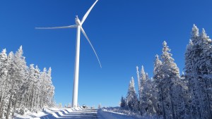
- Broadband to wind turbines and solar farms.
- Fiber connections to small cell sites.
- Broadband electric substations. I have several electric company clients that are in the process of extending broadband to a huge number of additional field assets like smart transformers and reclosers.
- Broadband to water pumps and other assets that control water and sewer systems.
- Broadband to grain elevators, corn dryers, and other locations associated with processing or storing crops.
- I’m working with several clients who are extending broadband for smart-city applications like smart streetlights, smart parking, and smart traffic lights.
- Broadband to smart billboards and smart road signs.
- Broadband for train yards and train switching hubs.
- There are many other examples, and this was just a quick list that came to mind.
The various locations described above have one thing in common. Most are locations that don’t have a 911 street address. As such, these locations are not being considered when trying to determine the national need for broadband.
A lot of these locations are rural in nature – places like grain elevators, mines, oil wells, irrigation systems, wind turbines, and others. In rural areas, these locations are a key part of the economy, and in many places are unserved or underserved.
We are putting a huge amount of national energy into counting the number of homes and businesses that have or don’t have broadband. In doing so, we have deliberately limited the definition of a business to a place with a brick-and-mortar building and a 911 address. But the locations above are often some of the most important parts of the local economy.
I’ve read predictions that say in a few decades there will be far more broadband connections to devices than to people, and that rings true to me. I look around at the multiple devices in my home that use WiFi, and it’s not hard to envision that over time we will connect more and more locations and devices to broadband.
After a decade of talking about the inadequate FCC broadband maps, we finally decided to throw money at the issue and devise new maps. But in the decade it took to move forward, we’ve developed multiple non-traditional uses for broadband, a trend that is likely to expand. If we are really trying to define our national need for broadband, we need to somehow make sure that the locations that drive the economy are connected to broadband. And the only way to do that is to count these locations and put them on the broadband map, so somebody tries to serve them. The current maps are doing a disservice by ignoring the huge number of these non-traditional broadband connections.
This problem should be split into two parts – manned and automated. The manned locations could be given addresses based on a road ID (state hwy., county road, farm-to-market, etc.) and a mile / klick (km.) post ID. The automated locations could be treated like the billboards in San Francisco which have an ID code and a proximity address.
In view of the potential for vandalism publication of exact GPS coordinates is probably too risky.
Instead, have a registry with the site’s ID code and the name of the owner or operator. The registry could also include aggregate information like owner X has Y locations along road Z.
P.S. The local fire departments may have addresses for the unmapped locations.